Lake Wind Advisory LAKE WIND ADVISORY - CSRA

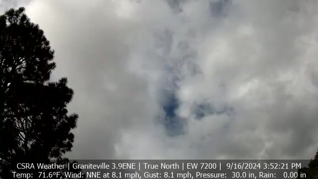
Current Image - Click To Access Full Screen

IPTimelapse.com - Past 4-6 Hours - Click To Access Full Screen

spacer
Updated: @ 11-Jan-2026 6:08am - next update at 12:00am  
Summary / Temperature Wind Rain Outlook
Night time, Dry, A few clouds Night time, Dry, A few clouds
Currently: 55.6°F, Max: 64.9°F, Min: 55.6°F 55.6°F
Colder 4.1°F than last hour.

---

Feels like: 56°F

24-hr difference
-8.7°FColder 8.7°F than yesterday at this time.
  Today Yesterday
High: 64.9°F
12:37am
80.9°F
2:03pm
Low: 55.6°F
6:07am
64.1°F
4:08am
 Wind from WSW WSW
1.8
Gust:
3.5 kts
1 Bft - Light Air
Today: 11.3 kts 5:49am
Gust Month: 13.9 kts January 10
Rain Today: 0 in
Rain Rate (/hr): 0 in
Rain Yesterday: 0 in
Storm Rain: 0 in
Month To Date: 0.28 in
Year To Date: 0.28 in
1 rain day in January.
Sunday

Sunday: Sunny
Sunny
Humidity & Barometer Almanac Moon
Humidity: 68 % Decreased 7.0% since last hour.
Dew Point: 45.2°F Decreased 6.6°F since last hour.
Barometer: 30.063 inHg Rising 0.02  inHg/hr
Baro Trend: Rising slowly
Sunrise: 7:31am
Sunset: 5:38pm
Moonrise: 1:20am
Moonset: 12:13pm
Waning Crescent
Waning Crescent, Moon at 22 days in cycle
42%
Illuminated
UV Index Solar Radiation
   0.0    None
High: 0.0 @ 12:00am
0 W/m2 (0 %)
High: 0 @  12:00am
National Weather Service History CSRA Region
Normal Rain Month:   3.72   in. Normal Rain YTD:  1.32  in.
Normal High:  56°F Normal Low:  34°F
Record High:  82°F  1949 Record Low:  6°F  1982
 NWS Weather Forecast  - Outlook: Overnight & Sunday
Overnight

Overnight: Slight Chance Rain Showers
Slight Chance Rain Showers

Lo 48 °F
NWS forecast: A slight chance of rain showers before 1am. Mostly cloudy. Low around 48, with temperatures rising to around 55 overnight. West wind 8 to 14 mph. Chance of precipitation is 20%. New rainfall amounts less than a tenth of an inch possible.
Davis VP+ forecast: Mostly clear and cooler.
 
Sunday

Sunday: Sunny
Sunny

Hi 56 °F
NWS forecast: Sunny. High near 56, with temperatures falling to around 49 in the afternoon. Northwest wind 14 to 18 mph, with gusts as high as 30 mph.

Image Courtesy of National Weather Service

Image Courtesy of National Weather Service

Click This Link To Access Full Screen/Current Regional Weather

Real-Time Air Quality Map Courtesy of Purple Air

Index.php Wide Script Courtesy of Clayton, North Carolina Weather